Litoral Province (Bolivia) Contents Location Population Division See also External links Navigation menu18°48′S 67°47′W / 18.800°S 67.783°W / -18.800; -67.78318°48′S 67°47′W / 18.800°S 67.783°W / -18.800; -67.783Population data (Spanish)e
AtahuallpaCarangasCercadoEduardo AvaroaLadislao CabreraLitoralPuerto de MejillonesNor CarangasPantaléon Dalence ProvincePoopóSajamaSan Pedro de TotoraSaucaríSebastián PagadorSud CarangasTomas Barrón
Provinces of BoliviaProvinces of Oruro Department
provinceBolivianOruro DepartmentHuachacallaSouthWestSajama ProvinceSabaya ProvinceSud Carangas ProvinceCarangas ProvinceSpanishAymaraQuechuacensuselectricitysanitary facilitiesagricultureindustrygeneral servicesCatholicsProtestantsmunicipalitiescantons
Litoral Province (Bolivia)
Jump to navigation
Jump to search
Litoral | |
|---|---|
Province | |
 Dawn in Sikiri, Litoral Province | |
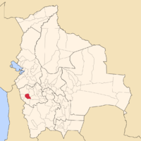
 Location of Litoral Province in Bolivia | |
| Coordinates: 18°48′S 67°47′W / 18.800°S 67.783°W / -18.800; -67.783Coordinates: 18°48′S 67°47′W / 18.800°S 67.783°W / -18.800; -67.783 | |
| Country | Bolivia |
| Department | Oruro |
| Capital | Huachacalla |
| Area | |
| • Total | 2,379 km2 (919 sq mi) |
| Population (2001) | |
| • Total | 4,555 |
| • Density | 1.9/km2 (5/sq mi) |
| • Ethnicities | Aymara |
| Languages spoken | |
| • Spanish | 89.8% |
| • Aymara | 76.0% |
| • Quechua | 13.7% |
| Sectors | |
| Time zone | UTC-4 (BOT) |
Litoral (or Litoral de Atacama) is a province in the southwestern parts of the Bolivian Oruro Department. Its seat is Huachacalla.
Contents
1 Location
2 Population
3 Division
4 See also
5 External links
Location
Litoral Province is one of sixteen provinces in the Oruro Department. It is located between 18° 32' and 19° 04' South and between 67° 29' and 68° 06' West.
The province borders Sajama Province in the north, Sabaya Province in the west and south, Sud Carangas Province in the southeast, and Carangas Province in the northeast.
The province extends over 65 km from north to south, and 55 km from east to west.
Population
The main language of the province is Spanish, spoken by 89.8%, while 76.0% of the population speak Aymara and 13.7% Quechua.
The population increased from 2,087 inhabitants (1992 census) to 4,555 (2001 census), an increase of more than 100%. - 34.5% of the population are younger than 15 years old.
94.5% of the population have no access to electricity, 90.5% have no sanitary facilities.
78.0% of the population are employed in agriculture, 3.1% in industry, 18.9% in general services (2001).
77.6% of the population are Catholics, 16.3% are Protestants (1992).
Division
The province comprises five municipalities which are further subdivided into cantons.

Municipalities of Litoral Province
| Section | Municipality | Seat |
|---|---|---|
| 1st | Huachacalla Municipality | Huachacalla |
| 2nd | Escara Municipality | Escara |
| 3rd | Cruz de Machacamarca Municipality | Cruz de Machacamarca |
| 4th | Yunguyo del Litoral Municipality | Yunguyo del Litoral |
| 5th | Esmeralda Municipality | Esmeralda |
See also
- Inka Murata
- Inka Qhamachu
- Pacha Qullu
- Qullpa Jawira
External links
- Population data (Spanish)
Categories:
- Provinces of Bolivia
- Provinces of Oruro Department
(RLQ=window.RLQ||[]).push(function()mw.config.set("wgPageParseReport":"limitreport":"cputime":"0.252","walltime":"0.341","ppvisitednodes":"value":3058,"limit":1000000,"ppgeneratednodes":"value":0,"limit":1500000,"postexpandincludesize":"value":38005,"limit":2097152,"templateargumentsize":"value":5418,"limit":2097152,"expansiondepth":"value":24,"limit":40,"expensivefunctioncount":"value":0,"limit":500,"unstrip-depth":"value":0,"limit":20,"unstrip-size":"value":0,"limit":5000000,"entityaccesscount":"value":1,"limit":400,"timingprofile":["100.00% 267.185 1 -total"," 94.57% 252.679 1 Template:Infobox_settlement"," 68.80% 183.833 1 Template:Infobox"," 16.43% 43.901 2 Template:Main_other"," 12.90% 34.463 1 Template:Coord"," 10.50% 28.056 1 Template:Infobox_settlement/areadisp"," 9.12% 24.379 2 Template:Infobox_settlement/metric"," 7.62% 20.363 2 Template:Rnd"," 6.62% 17.676 1 Template:Pagetype"," 5.35% 14.306 1 Template:Oruro_Department"],"scribunto":"limitreport-timeusage":"value":"0.073","limit":"10.000","limitreport-memusage":"value":2926899,"limit":52428800,"cachereport":"origin":"mw1332","timestamp":"20190522063720","ttl":2592000,"transientcontent":false););"@context":"https://schema.org","@type":"Article","name":"Litoral Province (Bolivia)","url":"https://en.wikipedia.org/wiki/Litoral_Province_(Bolivia)","sameAs":"http://www.wikidata.org/entity/Q388758","mainEntity":"http://www.wikidata.org/entity/Q388758","author":"@type":"Organization","name":"Contributors to Wikimedia projects","publisher":"@type":"Organization","name":"Wikimedia Foundation, Inc.","logo":"@type":"ImageObject","url":"https://www.wikimedia.org/static/images/wmf-hor-googpub.png","datePublished":"2005-08-22T02:52:04Z","dateModified":"2017-05-24T07:16:49Z","image":"https://upload.wikimedia.org/wikipedia/commons/7/73/Amanecer_en_Sik%27iri.JPG","headline":"province of Bolivia"(RLQ=window.RLQ||[]).push(function()mw.config.set("wgBackendResponseTime":102,"wgHostname":"mw1239"););
