ウェストランド・タイ・ポウティニ国立公園 目次 自然 歴史 アクティビティ 脚注 外部リンク 案内メニュー南緯43度23分 東経170度11分 / 南緯43.383度 東経170.183度 / -43.383; 170.183南緯43度23分 東経170度11分 / 南緯43.383度 東経170.183度 / -43.383; 170.183FeaturesFox Glacier Te Moeka o Tuawe Valley WalkFranz Josef Glacier/Kā Roimata o Hine Hukatere Walkウェストランド・タイ・ポウティニ国立公園ニュージーランド環境保全省のホームページ編歴
IUCNカテゴリーIIニュージーランドの世界遺産世界遺産 あ行ニュージーランドの国立公園南島 (ニュージーランド)オセアニアの谷
ニュージーランドアオラキ/マウント・クック国立公園1960年南アルプス山脈オーストリア帝国フランツ・ヨーゼフ1世マオリ語フォックス氷河マオリ族ヒスイ金アオラキ/マウント・クック国立公園トラッキング登山スキーマウンテンバイクカヤック
ウェストランド・タイ・ポウティニ国立公園
ナビゲーションに移動
検索に移動
| Westland Tai Poutini National Park | |
|---|---|
IUCNカテゴリII(国立公園) | |
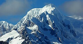
 タスマン山 | |
| 地域 | |
| 最寄り | ホキティカ |
| 座標 | 南緯43度23分 東経170度11分 / 南緯43.383度 東経170.183度 / -43.383; 170.183座標: 南緯43度23分 東経170度11分 / 南緯43.383度 東経170.183度 / -43.383; 170.183 |
| 面積 | 1,175 km² |
| 創立日 | 1960年 |
| 運営組織 | ニュージーランド環境保全省 |
ウェストランド・タイ・ポウティニ国立公園(Westland Tai Poutini National Park)とは、ニュージーランドの南島にあるアオラキ/マウント・クック国立公園の西隣に位置する国立公園。1960年に国立公園に指定された。面積は1,175km2で、南アルプス山脈の氷河が公園に含められている。多くの湖、さらに沿岸に沿って古い金採掘現場もある。
目次
1 自然
2 歴史
3 アクティビティ
4 脚注
5 外部リンク
自然

フランツ・ジョセフ氷河

フォックス氷河
ウェストランド・タイ・ポウティニ国立公園はタスマン海からわずか10キロメートルしか離れていない。しかし、海岸線からわずか10キロメートルで2000メートルを越える急峻な山々が聳え立つ。
急峻な山々の渓谷には、2つの著名な氷河がある。1つが1865年に、オーストリア帝国の地理学者ユリウス・フォン・ハーストが探検し、皇帝フランツ・ヨーゼフ1世にちなんで名づけたフランツ・ジョセフ氷河(マオリ語:Ka Roimata o Hinehukatere)である。もう1つがフランツ・ジョセフ氷河の南25キロメートルに位置するフォックス氷河であり、こちらは、1869年から1872年にニュージーランドの首相を務めたウィリアム・フォックスにちなむ。2つの氷河は、ともに、温帯多雨林が生育しているところまで、氷河の先端が延びている。
歴史
現在のウェストランド・タイ・ポウティニ国立公園に最初に居住したのは、マオリ族の人々である。彼らは、ヒスイを探しているうちに、定住した[1]。
ヨーロッパ人がこの地に退去して住むようになったのは、国立公園内で金が発見された1864年から、1865年のことであり、ピークで、鉱夫は16,000人に達した[1]。しかし、この地域に訪れたゴールド・ラッシュは、1年半も経つと雲散霧消し、ゴーストタウンのみが残された[1]。
この地域が観光地として脚光を浴びるのは、1900年代に入ってからのことである[1]。公園内に残る氷河が観光の目玉となった。東に隣接するアオラキ/マウント・クック国立公園の拡張も提案されたが、1960年3月29日、独立した形の国立公園となった[1]。1983年には、カラングア渓谷上流部が国立公園に編入され、さらに、2002年、2010年にも拡張されている。
アクティビティ
ウェストランド・タイ・ポウティニ国立公園では、さまざまなアクティビティが行われている。トラッキング、登山、スキー、マウンテンバイク、カヤックが行われているが、この国立公園の最大の観光スポットは、2つの氷河である。2つの氷河の上を歩く氷河ウォークとは、フォックス氷河ヴァレーウォーク[2]とジョセフ氷河ウォークである[3]。
脚注
- ^ abcde“Features”. Department of Conservation. 2013年9月22日閲覧。
^ “Fox Glacier Te Moeka o Tuawe Valley Walk”. Department of Conservation. 2013年9月22日閲覧。
^ “Franz Josef Glacier/Kā Roimata o Hine Hukatere Walk”. Department of Conservation. 2013年9月22日閲覧。
外部リンク
- ニュージーランド環境保全省のホームページ
| ||||||||
カテゴリ:
- IUCNカテゴリーII
- ニュージーランドの世界遺産
- 世界遺産 あ行
- ニュージーランドの国立公園
- 南島 (ニュージーランド)
- オセアニアの谷
(window.RLQ=window.RLQ||[]).push(function()mw.config.set("wgPageParseReport":"limitreport":"cputime":"0.204","walltime":"0.324","ppvisitednodes":"value":1632,"limit":1000000,"ppgeneratednodes":"value":0,"limit":1500000,"postexpandincludesize":"value":53488,"limit":2097152,"templateargumentsize":"value":3482,"limit":2097152,"expansiondepth":"value":20,"limit":40,"expensivefunctioncount":"value":4,"limit":500,"unstrip-depth":"value":0,"limit":20,"unstrip-size":"value":2351,"limit":5000000,"entityaccesscount":"value":1,"limit":400,"timingprofile":["100.00% 257.855 1 -total"," 52.16% 134.509 1 Template:Infobox_protected_area"," 48.03% 123.856 1 Template:Infobox"," 18.57% 47.880 1 Template:Infobox_coord"," 16.16% 41.681 1 Template:Coord"," 16.02% 41.310 3 Template:Cite_web"," 12.90% 33.266 1 Template:ニュージーランドの国立公園"," 10.56% 27.224 3 Template:Accessdate"," 8.81% 22.712 3 Template:Accessdate/core"," 8.19% 21.119 1 Template:Commonscat"],"scribunto":"limitreport-timeusage":"value":"0.043","limit":"10.000","limitreport-memusage":"value":1616223,"limit":52428800,"cachereport":"origin":"mw1252","timestamp":"20190409080011","ttl":2592000,"transientcontent":false););"@context":"https://schema.org","@type":"Article","name":"u30a6u30a7u30b9u30c8u30e9u30f3u30c9u30fbu30bfu30a4u30fbu30ddu30a6u30c6u30a3u30cbu56fdu7acbu516cu5712","url":"https://ja.wikipedia.org/wiki/%E3%82%A6%E3%82%A7%E3%82%B9%E3%83%88%E3%83%A9%E3%83%B3%E3%83%89%E3%83%BB%E3%82%BF%E3%82%A4%E3%83%BB%E3%83%9D%E3%82%A6%E3%83%86%E3%82%A3%E3%83%8B%E5%9B%BD%E7%AB%8B%E5%85%AC%E5%9C%92","sameAs":"http://www.wikidata.org/entity/Q1053661","mainEntity":"http://www.wikidata.org/entity/Q1053661","author":"@type":"Organization","name":"Contributors to Wikimedia projects","publisher":"@type":"Organization","name":"Wikimedia Foundation, Inc.","logo":"@type":"ImageObject","url":"https://www.wikimedia.org/static/images/wmf-hor-googpub.png","datePublished":"2005-02-05T11:00:48Z","dateModified":"2018-04-10T10:56:34Z","image":"https://upload.wikimedia.org/wikipedia/commons/b/bd/Mount_Tasman_2.jpg"(window.RLQ=window.RLQ||[]).push(function()mw.config.set("wgBackendResponseTime":134,"wgHostname":"mw1271"););